
A leading climate expert in Spain has said it is ‘too early’ to determine if a ‘Super El Niño’ will occur this year – adding that its impact on the Iberian Peninsular would not be very noticeable either way.
The verdict was made by Paloma Trascasa, an investigator at the Barcelona Supercomputing Center – Centro Nacional de Supercomputacion (BSC-CNS).
Speaking to the Spanish Eye this week, Trascasa calmed fears that the weather system would wreak havoc in Spain this summer, contrasting recent reports in Spanish newspapers.
El Niño refers to a climate pattern marked by unusually warm surface temperatures in the central and eastern Pacific Ocean, typically peaking around Christmas.
It acts as a global climate disruptor by weakening trade winds and driving worldwide weather changes, such as wet winters in the southern US, droughts in Asia, and higher global temperatures.
So what is a ‘super El Niño’ and are we headed for one?
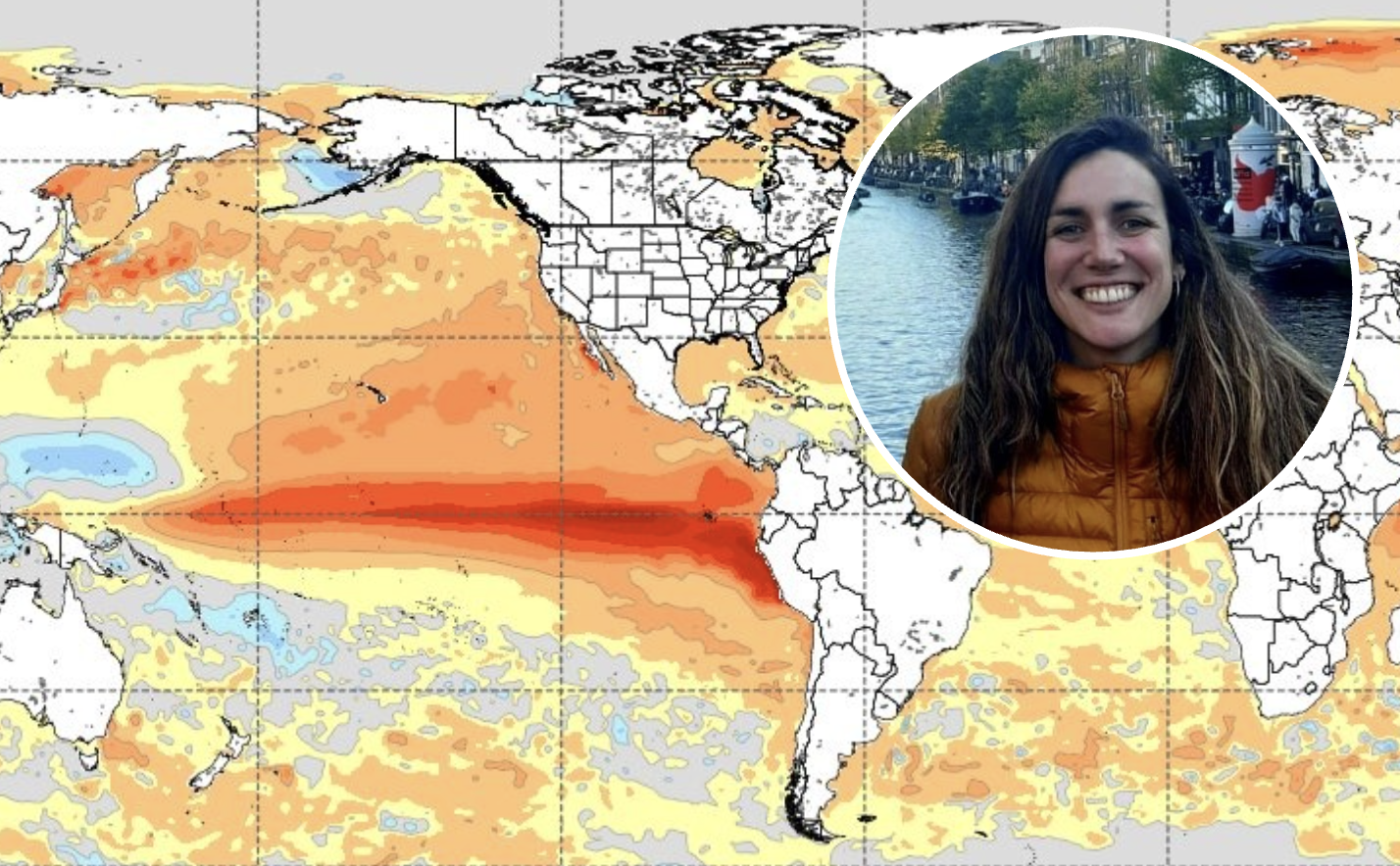
Trascasa explained to the Spanish Eye: ‘The main difference between a “super El Niño” and a moderate or weak event lies in the intensity of sea surface temperature anomalies in the equatorial Pacific Ocean.
‘El Niño is generally considered active when anomalies in the Niño 3.4 region (in the central-eastern equatorial Pacific) exceed 0.5C.
‘Although there is no strict definition of a “super El Niño,” some meteorologists use the term when temperatures in the monitoring region exceed 2C for several consecutive months.’
Regardless of the definition, Trascasa maintained that the phenomenon’s effects in Spain are ‘not very significant’.
She said: ‘While there is strong scientific evidence of El Niño’s teleconnections – or indirect impacts – on North America and Europe via the North Atlantic, particularly in boreal winter, its effects in Spain are generally not very significant.
‘During late autumn through winter, El Niño may lead to negative anomalies in the North Atlantic Oscillation (NAO).
‘This can weaken the Icelandic low and the Azores high, shifting the jet stream toward southern Europe and potentially bringing a slightly wetter and warmer winter than usual.
‘However, the strength of these anomalies – and El Niño’s influence on them – can vary significantly from year to year due to natural climate variability.’
Global temperatures to rise
According to Trascasa, the effects of a so-called super El Niño are more likely to be felt more strongly elsewhere in the world.
She explained: ‘El Niño typically brings above-average rainfall to eastern Africa, coastal Peru, northern Argentina, Uruguay, and the southern United States. It also tends to cause drier conditions in northeastern South America, Australia, India, and southern Africa.
‘El Niño and La Niña usually peak during the boreal winter months (December–January–February). After that, during El Niño years, the ocean gradually releases the excess heat it has accumulated into the atmosphere.

‘This leads to a slight increase in global temperatures in the months following the peak. In this case, the global temperature effects are expected to be noticeable in 2027.’
It comes after some meteorologists warned Spain could face a ‘furnace’ of a summer due to the phenomenon.
However, Trascasa insisted: ‘As mentioned earlier, El Niño does not have a strong or consistent impact on the Iberian Peninsula.
‘Across Europe, any influence tends to appear between late autumn and early winter 2026.’
Even so, any predictions about what will happen will be much more trustworthy from May.
‘At present, the NOAA estimates an 80% probability of El Niño conditions developing this summer, so there is strong confidence that an event will occur this year,’ Trascasa said.
‘However, its magnitude remains uncertain. Predicting El Niño in spring is particularly difficult due to the so-called “spring predictability barrier,” which makes changes in the tropical Pacific harder to forecast at this time of year.
‘From May onwards, the coupling between the ocean and atmosphere strengthens, improving forecast reliability.’
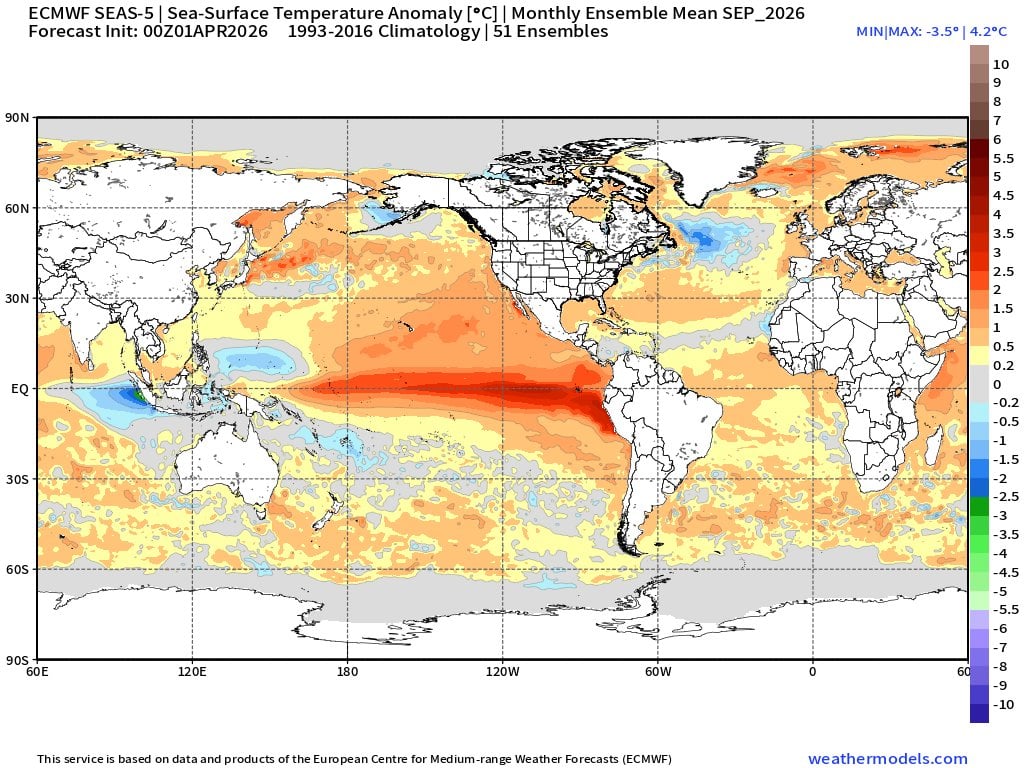
She added: ‘Climate models from the Copernicus Climate Change Service suggest a wide range of possible intensities, from 0.2C to 3.3C. This means it’s too early to say whether a “super El Niño” will occur.
‘This uncertainty is shared by major forecasting centres such as NOAA and the ECMWF. Monitoring conditions month by month will be key, with clearer projections expected closer to autumn.’
So is climate change playing a role in the strengthening of the El Niño?
For Trascasa, it’s impossible to say with 100% certainty, as there would need to be a detailed study.
She said: ‘Climate change is causing oceans to warm rapidly, which alters circulation patterns. However, determining whether climate change has made a specific El Niño event stronger or weaker requires a detailed post-event attribution study.
‘Looking ahead, many studies suggest that climate change will increase the variability of the El Niño–Southern Oscillation (ENSO), meaning more extreme El Niño and La Niña events could occur.
‘That said, there is still considerable uncertainty in long-term projections, as climate models do not yet fully capture how the equatorial Pacific will respond to warming. There is no full scientific consensus on this issue.
‘What is clear, however, is that global temperatures are rising due to human-driven greenhouse gas emissions. A warmer atmosphere can hold more moisture, which increases rainfall intensity.
‘As a result, both El Niño and La Niña events are expected to produce more intense rainfall, especially in tropical regions.’