
After months of relentless rain, a ‘carousel’ of Atlantic storms and widespread flooding, residents across southern Spain insist this is the worst winter in decades.
- A winter that stands out – especially after years of drought
- Cold winter? Not quite – despite how it feels
- Weather versus climate: Why storms don’t equal climate change
- The large-scale patterns driving this winter
- Is this the ‘new normal’ for Spain’s winters?
- Tornados, hurricanes and Mediterranean storms
- What are the real risks for southern Spain?
But debate has emerged over whether this winter has been truly exceptional, and if climate change is to blame.
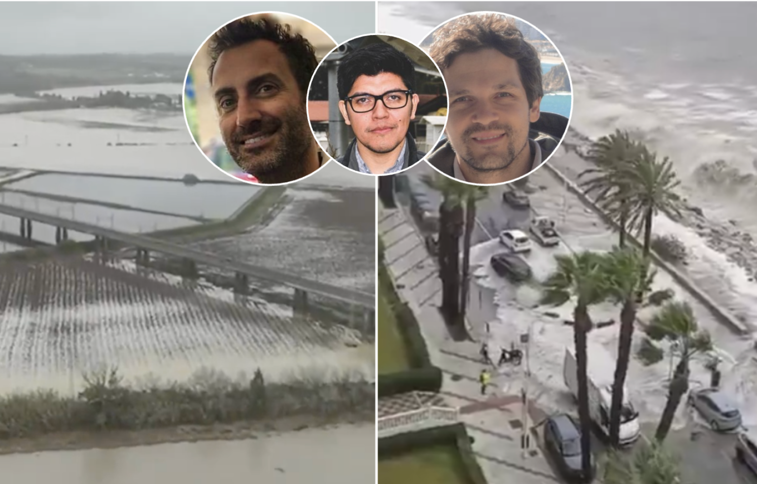
The Spanish Eye has spoken exclusively to Diego Campos, Stefano Materia and Ramiro Saurral, three investigators from the Barcelona Supercomputing Centre – Centro Nacional de Supercomputacion (BSC-CNS), to unpack what is really happening behind one of the wettest and stormiest winters Spain has experienced in years.
Their conclusion is nuanced: this winter is unusual, particularly compared with recent years – but it cannot yet be directly attributed to climate change.

A winter that stands out – especially after years of drought
According to the researchers, the winter of 2025–2026 has several features that justify describing it as exceptional, particularly in the context of recent Spanish winters.
‘The most striking signal is not just how much rain has fallen, but how often it has rained,’ they explained.
‘Since early December, large parts of Spain have experienced an unusually high number of wet days, producing long stretches of grey, unsettled weather.’
This pattern has been especially pronounced in western and southern regions, including Andalucia, Extremadura, Galicia and Portugal, while eastern and Mediterranean areas have also been affected by repeated storm systems.
Scientists explain that this has been driven by a ‘southward shift of the subpolar jet stream, which has allowed Atlantic low-pressure systems to track repeatedly across the Iberian Peninsula.’
These systems are typically associated with strong winds, heavy rain and coastal swell – all of which have featured prominently this winter.
Mountain regions have also felt the impact, the experts said.
‘Increased precipitation days have pushed snowfall totals towards record levels in parts of the Pyrenees and Sierra Nevada, offering a stark contrast to recent winters marked by poor snow cover,’ they explained.
They added that what makes this winter feel particularly dramatic is its contrast with the previous three, when storms were displaced further north and Spain remained largely dry.
Cold winter? Not quite – despite how it feels
Although the winter has felt cold to many, temperature data tells a more restrained story.
Average temperatures have been close to normal when measured against the 1991–2020 climate reference period.
‘The perception of a cold winter is partly explained by the fact that recent winters have been unusually mild, making this one feel harsher by comparison,’ the researchers explained.
In fact, scientists note that Spain would have to go back to winter 2020–2021 to find a season that was both colder than average and colder than the current one.
Weather versus climate: Why storms don’t equal climate change
A key message from the experts is the need to separate short-term weather from long-term climate trends.
They agreed that at present, ‘there is no scientific evidence proving that climate change is directly responsible for this winter’s high frequency of storms or rainfall’.
In fact, many climate studies suggest that global warming tends to push jet streams poleward, not southward – the opposite of what has been observed this winter.
‘This does not contradict climate change theory,’ they insisted, ‘Instead, it highlights the role of natural climate variability, which can temporarily mask long-term trends.’
Before linking an event like this winter to climate change, they said that scientists would first need to demonstrate that it ‘falls outside the bounds of natural variability’, and then apply formal attribution studies using climate models – work that takes time.
The large-scale patterns driving this winter
The experts said that several atmospheric factors have combined to shape the current situation:
Negative NAO (North Atlantic Oscillation):
This winter has been dominated by a negative NAO phase, favouring storm tracks into southern Europe.
This contrasts sharply with recent winters, which were largely NAO-positive (sending storms north) and much drier in Spain.
Jet stream displacement:
The polar jet stream has shifted southwards, increasing the frequency and intensity of Atlantic storms and so-called atmospheric rivers reaching the Iberian Peninsula.
A warm Mediterranean – but not the main driver:
Sea surface temperatures in the Mediterranean have been above average, but this is not unique to this winter and was also the case during recent dry years.
While warmer seas can increase moisture availability, this mechanism tends to play a larger role in non-winter storms.
La Niña conditions:
Weak La Niña conditions are present, but scientists stress that this phenomenon has little influence on Mediterranean winters.
Is this the ‘new normal’ for Spain’s winters?
Looking ahead, climate models paint a complex and sometimes contradictory picture, the experts revealed.
They said most global models project a long-term drying trend across the Mediterranean, including southern Spain, particularly under higher greenhouse gas emission scenarios.
However, uncertainty remains high, and observed trends so far appear strongly influenced by natural variability, such as the NAO.
What scientists agree on more confidently is that average rainfall may decrease, but extreme rainfall events are likely to become more intense.
In practice, that could mean:
- Fewer rainy days overall
- Rain falling in shorter, more violent bursts
- Greater flood risk, even if annual totals do not increase
The experts said: ‘Global models project a drying of the Mediterranean in the future, including southern Spain, especially under scenarios with higher greenhouse gas emissions.
‘However, uncertainty remains high due to a lack of consensus on current trends. Only some regions of the Mediterranean have shown significant trends in recent decades, and these appear to be driven by natural variability (such as the positive trend of the North Atlantic Oscillation) rather than anthropogenic factors.
‘At the same time, there is evidence that increased atmospheric warming, caused by global warming, and a rise in sea surface temperature could lead to an increase in extreme precipitation events.
‘This suggests a future of lower average precipitation but more frequent and extreme precipitation events.’
Tornados, hurricanes and Mediterranean storms
Despite frequent speculation on social media, experts say there is no solid evidence suggesting Spain will see more tornados in the future. Tornados and large hail are highly localised phenomena and remain extremely difficult to model.
As for hurricanes, a direct tropical cyclone impact on mainland Spain remains very unlikely. However, there is a realistic risk of post-tropical systems or ‘medicanes’ bringing heavy rain and strong winds into the western Mediterranean.
The experts explained: ‘As far as we know, there are no scientific studies projecting an increase in the frequency of tornados over Spain.
‘Furthermore, both tornados and hail are small-scale phenomena that are difficult to simulate and predict. This results in a limited body of literature on the subject, given the complexity of their study.
‘Regarding hurricanes, it remains highly unlikely that a pure tropical cyclone will impact the Iberian Peninsula, although it is possible that tropical cyclones could move towards Europe and reach the continent as post-tropical cyclones.’
What are the real risks for southern Spain?
Looking 10 to 30 years ahead, scientists highlight several practical risks for Andalucia, but one is among the most concerning.
They said: ‘Undoubtedly, one of the main risks during future winters will be the scarcity of snow.
‘Although there may be years with abundant snowfall (like the current one), the trend indicates that such events will become increasingly less frequent in the context of global warming.
‘The main associated impact will be on water availability in regions whose spring and summer water supply depends on the amount of snow received the previous winter.
‘It will also have a potentially significant impact on tourism.’
This winter has been exceptional in its persistence and intensity, particularly after years of drought.
But according to climate experts, it is best understood as a product of natural atmospheric variability, not as definitive proof of climate change.
The longer-term picture is more concerning – not because every winter will look like this one, but because Spain is likely to face a future of fewer averages and more extremes.
Read more Andalucia news at the Spanish Eye.