Snow is set to fall on certain areas of Malaga province this weekend as a new Atlantic front sends temperatures plummeting.
The passage of Storm Emilia has already left the white stuff on some of the highest peaks, including La Maroma in the Axarquia and at Cañada del Cuerno in the Sierra de las Nieves.
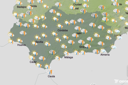
New Atlantic fronts are set to arrive from Friday, bringing rain, falling temperatures and a lower snow line, according to forecasts from Spain’s state weather agency, Aemet.
This new period of atmospheric instability will see rain begin later in the day and could continue through to Monday, meaning the weekend is unlikely to be settled or sunny.
The snow level is expected to sit between 1,800 and 1,900 metres on Friday, remaining around 1,800 metres on Saturday, before dropping to around 1,500 metres on Sunday.
At this level, snow could appear in very high inland areas, including El Torcal.
Looking further ahead, forecast models suggest that by Christmas Eve (December 24) the snow line could drop to around 1,200 metres in eastern Malaga province.
Rain is expected to arrive on Friday evening, with the heaviest accumulations initially forecast along the coast:
- Torremolinos: up to 14.5mm per square metre in one hour
- Mijas: 9.5 mm
- Fuengirola: 8.8 mm
- Malaga city: 7.5 mm
These amounts are forecast between 6pm and 8pm.
Rain is also expected on Saturday, but Sunday is forecast to be the wettest day, with a near-100% chance of precipitation across the province.
The start of next week is expected to be colder than average, with several weather systems moving through southern Spain.
As a result, unsettled conditions are likely to continue into the Christmas period.