Andalucia is bracing for one of the most dangerous weather setups of the winter, as a powerful tropical atmospheric river collides with Storm Leonardo.
The clash is creating the conditions for extreme rainfall, flash flooding and river overflow over several days.
After weeks of rain, much of southern Spain is already saturated. Now, forecasters warn that the next system will bring ‘rain on rain’ – the worst possible scenario for flooding.
Andalucia has cancelled school across the region – except in Almeria – and has called in military troops as a precaution.
What is an atmospheric river?
An atmospheric river is a long, narrow corridor of extremely moist air that transports huge volumes of water vapour from the tropics – in this case, from the Caribbean – towards Europe.
When this moisture hits a weather front or mountainous terrain, it is released as intense, prolonged rainfall.
Meteorologists compare strong atmospheric rivers to flying rivers: they can release more water in a few hours than many regions receive in an entire month.

Why Andalucia is especially at risk
From Tuesday night into Wednesday, the tropical moisture plume will merge with Storm Leonardo, dramatically intensifying rainfall over western and southern Spain – with Andalucia firmly in the firing line.
According to forecasts from ElTiempo.es, the most severe impacts are expected between Wednesday and Thursday, when rainfall rates could become torrential.
The danger is magnified because:
- Soils are already fully saturated
- Rivers are running high after weeks of rain
- Additional rainfall will run straight off, rather than being absorbed
This significantly increases the risk of flash floods, river bursts and landslides.
Red alerts issued for Grazalema and Ronda
Authorities have issued red-level rain warnings for Grazalema and Ronda, where rainfall could exceed:
- 200 mm in 24 hours
- 30 mm in just one hour
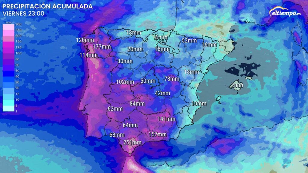
Orange alerts are in place across large parts of Cadiz, Malaga, Granada and Jaen, with totals of up to 100 mm in 12 hours possible.
In plain terms: this is rainfall capable of overwhelming drainage systems and river channels very quickly.
When will it be worst?
- Tuesday: Widespread rain across Spain, lighter than Monday but persistent
- Tuesday night – Wednesday: Rapid intensification as the atmospheric river arrives
- Wednesday: Peak risk for Andalucia, with torrential downpours
- Thursday: Potentially the most severe day, as another active front arrives
- Friday: Rain continues, easing only slowly
Total accumulations by the end of the week could exceed 250 mm in parts of Cadiz and 150 mm in western Galicia.
Snow adds to the danger
Cold air higher in the atmosphere means snowfall in northern and central Spain, particularly in Castilla y Leon, Aragon and the central mountain ranges. As temperatures rise later in the week, snowmelt combined with rain could further swell rivers.
Why flood risk is unusually high
Hydrological models point to exceptionally elevated flood risk, especially in:
- Western and southwestern river basins
- Areas close to riverbanks and flood plains
- Mountain foothills where runoff accelerates
With the ground already unable to absorb more water, river levels could rise very quickly, leaving little time to react.
The combination of a tropical atmospheric river, repeated Atlantic fronts and saturated terrain makes this one of the most high-risk weather patterns Spain sees.
Authorities are urging residents to:
- Avoid riverbanks and flood-prone areas
- Limit non-essential travel during peak rainfall
- Follow official warnings closely
Read more Andalucia news at the Spanish Eye.