
British expats have claimed this is the worst winter in Spain for decades following weeks of prolonged rain and wind.
Spanish Eye readers have commented that they are ‘fed up’ of the non-stop storms that have been sweeping the region since November.
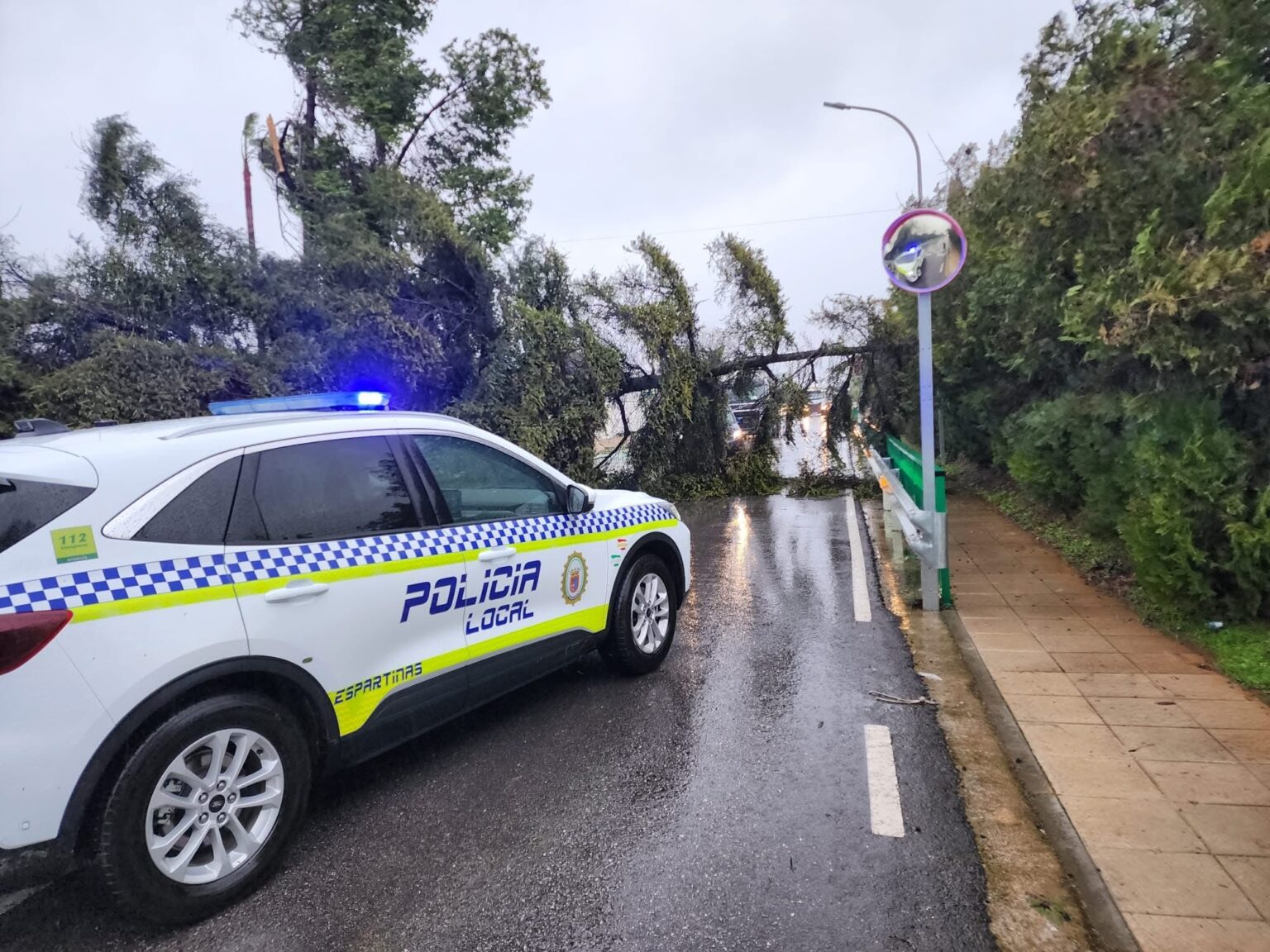
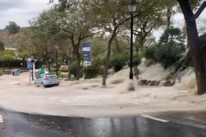
The end of January has been particularly wet, with prolonged downpours leading to the uprooting of hundreds of trees during the passing of Storm Kristin this week.
After a calmer Saturday, it appears a fresh week of rainfall is due for the whole of Andalucia from Sunday evening.
It’s bad news for sun-loving Brits, who already feel this is the worst winter for years in terms of prolonged downpours and storms.
Phil Jones said: ‘In over 35 years, I have never known a winter like this. Sure, it’s been colder, but only for a few days. This has been going on for more than three months now.’
Vonney Dahling added: ‘I have been here 15 years but never experienced anything quite this bad for so long.’

Sue Lang, agreed, saying: ‘I’ve been here for 25 years and never had this continuous weather before. So it’s not just winter, it’s changing weather patterns!’
‘This is not a normal winter,’ added another reader.
Marje Turner said: ‘It’s the coldest and wettest winter in 40 years and one storm after another… never seen a winter like it here in Spain.’
Another said: ‘The weather this winter has been the worst I can recall in over 20 years living here and it’s dragged on and on.’
Outlook for Andalucia next week
According to state weather agency Aemet, a powerful Atlantic storm will sweep into the region on Sunday evening, bringing heavy rain, thunder and strong gales.
Current forecasts show the majority of the region is expected to see rain every day next week, including Huelva, Sevilla, Cadiz and Malaga – even on the Costa del Sol.
Aemet says this is due to a series weather fronts expected to arrive over the following days, prolonging unsettled conditions.
Saturday is expected to act as a transition day, although weather warnings remain in place. Alerts for strong winds and rough seas continue along the coast of Almeria and Granada, while wind warnings also remain active in Jaen.
Rain is forecast to return on Sunday as a humid air mass moves in from the Atlantic.
A weather front is then expected to enter from the west and sweep across Andalucia throughout the day, with rainfall generally lighter in Almeria.
Temperatures are forecast to remain stable or rise slightly, with daytime highs averaging around 16C and night-time lows close to 10C. Winds along the coast are expected to be light to moderate.
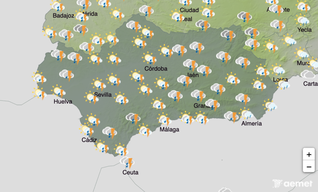
The most significant deterioration in conditions is expected overnight from Sunday into Monday, when a deep low-pressure system moves in from the north-west of the Iberian Peninsula.
This storm is forecast to bring overcast skies and widespread rainfall across mainland Spain, the Balearic Islands and Andalucia.
While no official weather warnings have yet been issued for Monday in Andalucia, Aemet has indicated that alerts are likely to be activated in the coming hours.
Forecasts point to persistent cloud cover with moderate rainfall spreading from west to east, becoming locally heavy and prolonged in some areas.
Temperatures are expected to fall, while westerly winds will strengthen throughout the day, becoming moderate to strong, with very strong gusts possible during the first half of Monday.
Residents are being advised to stay alert to updates as the evolving forecast may lead to further warnings being issued at short notice.
Read more Andalucia news at the Spanish Eye.