
A late-summer DANA could bring severe weather to parts of Spain between Sunday and Monday, state weather agency Aemet has warned.
The most at risk areas are the Balearics and the Costa Blanca and Valencia, where yellow and orange alerts have been issued – although Andalucia won’t get off scot-free.
In Andalucia, Friday passed without incident, marked by mostly clear skies and mild temperatures for late August.
Saturday is expected to remain mostly calm across the region, though scattered afternoon thunderstorms may develop over mountainous areas in the eastern interior.
Daytime highs will hover around 35C in Granada, Jaen, Cordoba, and Seville, with the rest of the region staying below 30C. Overnight lows will remain steady around 20°C.
Electric storm risk from Sunday
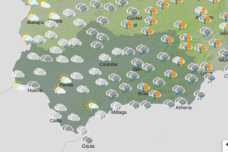
Starting Sunday, cloud cover will increase significantly in Andalucia, especially in the eastern third of the region. Showers and thunderstorms are possible from the afternoon onward as the DANA (an isolated high-altitude depression) moves closer to the Iberian Peninsula.
Minimum temperatures will hold steady, while maximums may dip slightly. On Monday, similar conditions are forecast, with continued cloudiness and a chance of rain and storms – again, most likely in eastern Andalucía.
Showers and thunderstorms are expected to return to parts of Andalucia beginning Sunday afternoon, particularly in the eastern and inland areas.
The most likely provinces to be affected are Granada, Jaen, and the interior of Malaga, where atmospheric instability linked to a DANA system could trigger localised downpours, hail, and gusty winds.
In Granada province, towns such as Granada city, La Zubia, Monachil, Orgiva, and other areas along the Sierra Nevada foothills are at risk of storm activity.
These locations could see heavy rain and electrical storms beginning Sunday afternoon and continuing intermittently through Monday.
In Jaen, similar conditions are expected in and around Jaen city, Ubeda, Baeza, and other interior towns.
The forecast suggests cloudy skies with a growing chance of isolated showers or thunderstorms, particularly during the late afternoon hours on both Sunday and Monday.
In Malaga province, although the coastal areas are expected to remain mostly dry, the interior – especially towns like Antequera, Competa, and Alhama de Granada – could also see storm development. The terrain in this part of the province makes it more prone to convective storms under the current forecast.
Western Andalucian provinces such as Cadiz, Huelva, and even Sevilla are not currently expected to be affected by this round of rainfall, with forecasts pointing instead to stable, dry, and warm conditions across those areas.
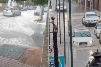
The rainfall, where it does occur, is expected to be brief but intense, typical of late summer DANA-driven storms. AEMET continues to monitor conditions and will issue weather warnings if necessary.
Read more Andalucia news at the Spanish Eye.