Andalucia is set for a burst of summer-like heat to round off Semana Santa, but forecasters are warning the sunshine won’t last.
According to state weather agency Aemet, the key holiday period from Maundy Thursday through to Easter Monday will be dominated by stable, dry weather and rising temperatures.
In many areas, thermometers will climb above 25C, with highs of up to 30C in the Guadiana and Guadalquivir valleys by Sunday and Monday.
Clear skies and settled conditions are expected to take hold from Good Friday as a high-pressure system strengthens over Spain, bringing near-perfect conditions for processions and travel across much of the country.
But the calm spell is expected to break early next week.
Storms and sharp temperature drop on the way
From Tuesday, a change in the weather pattern could bring a marked shift, with the arrival of a low-pressure system expected to trigger rain and storms across large parts of Spain, including Andalucia.
Weather experts at Meteored warn that the system could develop into a powerful Atlantic storm, potentially undergoing explosive cyclogenesis, although there remains some uncertainty.
If confirmed, the system would arrive as an active cold front, dragging in polar maritime air and creating the conditions for widespread instability.
That could lead to what forecasters describe as the first significant storm episode of the spring.
Showers and thunderstorms are expected to sweep from west to east between Tuesday and Thursday, with the potential for locally intense downpours, particularly in Andalucia, Extremadura, Castilla-La Mancha and Madrid.
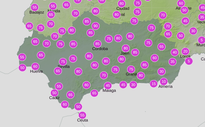
When and where rain is most likely
Current forecasts from Aemet put the probability of rainfall in Andalucia on Tuesday at between 30% and 90%, depending on the area.
The highest risk is expected inland, particularly in provinces such as Sevilla, Cordoba, Granada, Malaga and Huelva, mainly from midday onwards.
Rain is considered less likely along the coast, especially in Cadiz and Almeria.
Temperatures will also drop noticeably, with maximums falling by more than five degrees to around 25-26C.
Looking further ahead, some models suggest the system could evolve into a DANA (cut-off low) near northern Morocco later in the week, a scenario that would prolong unsettled conditions.
Read more Andalucia news at the Spanish Eye.