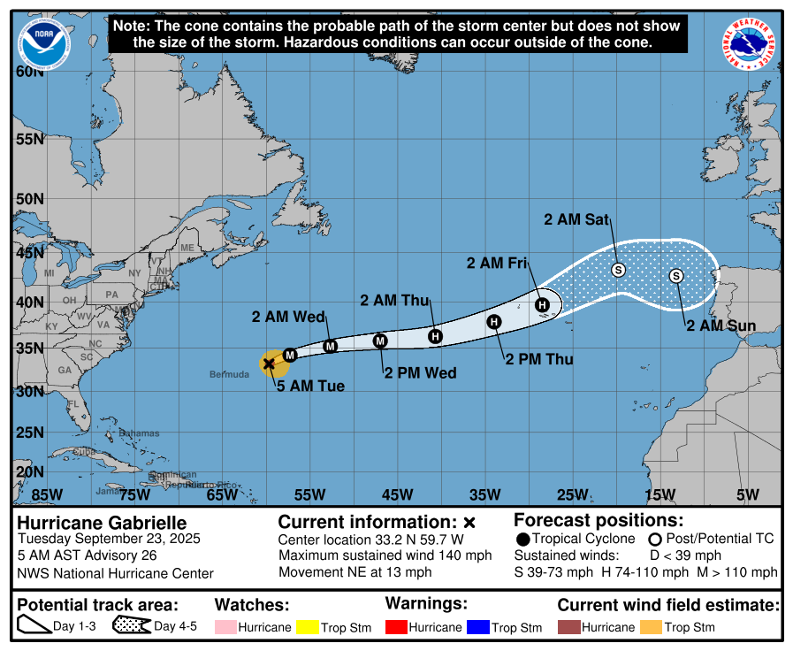

While Hurricane Gabrielle is not expected to make landfall in Spain, the resulting storm system will impact parts of the country, including Andalucía.
At the moment, Gabrielle is located in the central Atlantic as a Category 4 hurricane, with sustained winds reaching around 220km/hr.
For context, Hurricane Katrina, one of the most infamous hurricanes on record, was a Category 5, the highest classification.
According to forecasts from eltiempo.es, Gabrielle is expected to move eastward towards the Azores, weakening to a Category 3 by Wednesday and reaching the islands as a Category 2 storm on Thursday.
Though still days away, the general projection is that Gabrielle will continue moving towards the Iberian Peninsula after passing the Azores.
By Friday, it is expected to lose its hurricane status and transform into a more typical autumnal low-pressure system, known in Spain as a borrasca.
Spain’s weather agency Aemet anticipates that this system could reach the country around Sunday, bringing unsettled weather along with it.
If this transition happens as predicted, Gabrielle – no longer a hurricane – could still cause significant weather changes in parts of Spain.
These may include rough seas, widespread cloud cover, rainfall, strong winds, and a noticeable drop in temperatures, particularly across the western half of the country.
For instance, Aemet’s latest weather maps suggest that maximum temperatures in Andalucía on Monday, September 29, will hover around 24C – a marked decrease compared to the recent heat.
There are still several possibilities regarding the storm’s exact path, especially once it crosses the Azores.
According to Angel Rivera, a veteran meteorologist formerly with Aemet, there are two main uncertainties.
First, whether Gabrielle will undergo a full extratropical transition, becoming a conventional Atlantic storm, or whether it will retain some of its tropical characteristics as a hybrid or post-tropical system, still capable of delivering heavy rain and strong winds.
Second, the question of where the system will go next remains open. It might head north towards the British Isles or the Bay of Biscay. But there’s another scenario that has gained traction in recent days.
Cadiz in the storm’s path
Forecast models from the European Centre for Medium-Range Weather Forecasts (ECMWF) have consistently pointed to the possibility of the storm curving south along the Portuguese coast and settling near the Gulf of Cadiz by Sunday or Monday.
If this trajectory plays out, Rivera suggests that it could bring substantial rainfall to southern Portugal and lower Andalucia. He has also shared visual data showing possible rainfall accumulation in the southwest of the peninsula between Sunday and Tuesday.
Despite these projections, the situation remains fluid. Meteorologists stress that nothing is certain yet, and the eventual outcome will depend heavily on how Gabrielle behaves over the coming days.
For now, all reliable forecasts agree on a few key points: Gabrielle will not strike Spain as a hurricane; its remnants may reach the peninsula in the form of a storm system; and Andalucía could be among the affected areas.
Aemet forecasts show increasing cloud cover across most of Andalucia on Monday, coinciding with the projected arrival of the storm system.
That date may also bring a significant drop in temperatures, adding to the seasonal shift already underway. What happens next will depend entirely on how the storm evolves once it moves out of the Atlantic.